Wednesday, 12 October 2011

Who's in the peloton?

An investigation of the growth of cycling in London

I have been meaning to lay my hands on the above-named document for some time. The authors of this report, TfL and MVA Consultancy, refused to share it with me, and neither is it available on their websites, but luckily, the London South Bank University were able to point me in the right direction.

The report notes, 'A unique opportunity to track (cycling) behaviour over time and understand the reasons for change.'

Having already established a baseline picture of cycling behaviour through existing monitoring, the study team were able to follow up with a further round of telephone interviews. 500 interviews were conducted with cyclists in Richmond and Sutton, of whom 64 were 'new cyclists'. (A new cyclist was defined as someone who was cycling once a month or more in September 2009 and who, one year previously, had been cycling once every six months or less.)

Over 75% of the sample had been resident in London for ten years or longer. Over 90% had access to a bicycle prior to their behavioural change. Around 35% did most of their cycling during peak periods. 66% had concerns before they started cycling.

There were three main groups of concerns: confidence and skills, facilities, and road and traffic conditions.

With regard to road and traffic conditions, the main issues were too much traffic / congestion, not trusting other road users, and a fear of being knocked off one's bike. With regard to facilities, a lack of cycle lanes / routes was cited as the main barrier, followed by a lack of showers and changing facilities, and finally, a lack of places to leave one's bike. As for confidence and skills, the major barrier in this category was, 'Don't know where to cycle'. (Remember, over 75% of respondents have been living in London for ten years or longer.)

In joint first place was too much traffic / congestion, and not trusting other road users. In joint second place was a lack of cycle lanes / routes, and not knowing where to cycle. And in third place was a fear of being knocked off one's bike.

A former Chief Executive of the London Cycle Campaign said, 'The endgame is the prioritisation, completion and signage of an effective London Cycle Network.' Assuming cycle training would always be at hand to those who want it, assuming more cycle parking would continue to be made available, assuming employers and colleges would meet an increase in demand for cycling by providing showers and changing facilities, the development of a London Cycling Network would represent a huge step forward in terms of dealing with those other 'concerns' that new cyclists have.

And how important are new cyclists to the current growth in trip rates? ANSWER = VERY.

So, which way now? How does TfL 'nudge' more people into cycling?

TfL have taken the trouble to understand their 'customers'. They know who is most likely to cycle. These people fall into four different categories: Urban Living, Suburban Lifestyle, Young couples and families, and High-earning professionals.

They know, as well, that there is great potential for cycling in London. 4.3 million journeys a day have been identified as potentially cyclable, by origin, by current mode, and by journey purpose. M'lud, 2.8 million of these journeys are currently being made by car. Every day, then, 165 million 'potatoes' are being 'consumed' unnecessarily. No wonder Britain is becoming so obese.

Interestingly, the main benefits of cycling were identified as health, and then general enjoyment / stress release. More convenient / able to get to more places came fourth.

In response to the above, TfL propose taking a targeted approach, focusing delivery on areas of high potential. These have been identified as short hops in Central London, commute trips from Inner to Central London, and local trips in Inner and Outer London (i.e. to the shops, school and work).

The current strategy involves the Cycle Superhighways and the Barclays Bike Hire Scheme. Both schemes are used mainly by young men. It doesn't look like this situation will change any time soon.

The following conclusions are drawn:

  • Understanding behaviour through targeted research is key to our work
  • Enabling a targeted approach to planning and delivery
  • In support of the cycling revolution which is underway in London.

Please click here to see the TfL / MVA Consultancy report.


If Antony Gormley ruled the world

He'd ban cars in cities.

He says, 'As a cyclist myself, it's encouraging that our tribe is growing bigger. But I think it's crazy that we still insist on cohabiting with cars in cities. In Paris there are so few cars now - Parisians really feel their city is theirs, their own communal living room, and they treat it with respect.'

Saturday, 8 October 2011

The London Cycling Network

I have finished laying down the course of the routes that make up a revitalised London Cycling Network. As always, these maps are best viewed with the terrain box ticked.

Navy Routes

Side-to-side routes 205.8 mi

Additional routes 45.1 mi

Total 250.9 mi


Red Routes

Side-to-side routes 221.4 mi

Additional routes 54.7 mi

Total 276.1 mi


Green Routes

Side-to-side routes 236.4 mi

Additional routes 35.3 mi

Total 271.7 mi


Cyan Routes

Side-to-side routes 255.2 mi

Additional routes 45.3 mi

Total 300.5 mi


Orange Routes

Side-to-side routes 213.2 mi

Additional routes 66.5 mi

Total 279.7 mi


Circular Routes

Total 11 mi


Grand total: 1389.9 mi


Average (not including Circular Routes) 275.8 mi
North-south ('cold' colours) 551.4 mi
East-west ('warm' colours) 555.8 mi

Certain sections of these routes are coded with more than one colour (bridges, for example), so the actual network distance is going to be somewhat less than the stated total. Something a little over 2200km would be my guess. But the LCN was 3000km, the LCN+ was 900km, and the Cycle Superhighways are whatever they are, and when you consider that pretty much all three networks are incorporated into this new design, you'd have to say that 2200km of network is not excessive, not by any stretch of the imagination.

Granted, the network as shown does not cover all of the Greater London area, and working out which routes should make up the rest of the network, and how they should be coded  - which I have looked at, but not for a while - is something that will need to be addressed.

To remind you, my proposal can be broken down into two parts:

i. a comprehensive, city-wide cycle network developed, in the first instance, to a minimum level of functioning; and

ii. a signing strategy which uses compass colours to distinguish one route from the next.

The first part of my proposal generally stands up well to criticism, such as I have heard, at any rate. The second part of my proposal is also fairly robust, but is more likely to be misunderstood. I will consider now those criticisms which are known to me.


Lower speed limits, dedicated bike lanes and priority at junctions will encourage new cyclists, not a load of signs. This map idea is dead before it's even started. (Michael Cave)


I’m having another of those moments where I feel like I’m the only person in the world who dislikes something. (To be clear: I dislike this map.) 
I’ve cycled in London. Not as much as some people, but for a year or two that was how I commuted, three to five times a week. I also did a few longer rides, and got to try the hire scheme before I moved away. 
I want to see there be more cycling in London. The problem is that this map doesn’t make it any easier. Instead, it abstracts away some complexity you need to understand (how to deal with one-way systems, for example) and replaces it with other complexity which you don’t (what is R1 and how is it different from R1a?) 
Remember, the Tube map can make compromises with geography because it is disconnected from the surface geography except at stations. By contrast, cyclists have to share the same messy, often medieval, street plan as everything else on the ground, and this map won’t show enough to let them do it. 
I’d much rather have the TfL/LCC cycling maps, large as they are, because they actually work. (I know. I used them.) On the other hand, perhaps everyone is liking and reblogging this because it’s colourful and pretty. Call it a nice artwork if you like, but I don’t think it’s good design. (Paul Mison)


Pretty, but not Practical. OK for a tube as you can't get lost between stops, but on a bike, I'd rather have the street map version to know where I really am. (Paul Adams)


Clearly my critics have not understood the detail of my proposal, which is how it goes sometimes. But 'dedicated bike lanes and priority at junctions' where? Tell me, and I'll see if I can code them. And do you actually need maps to show you 'how to deal with one-way systems' if the routes on this network are functional in both directions? No, as I say, these aren't criticisms, they're misunderstandings.

The second part of my proposal is a signing strategy which uses compass colours to distinguish one route from the next, and 'this map idea' is a way of conveying that in a stylised form.

'A map is a graphic representation of a portion of the earth's surface drawn to scale, as seen from above. It uses colours, symbols, and labels to represent features found on the ground.'

'A map provides information on the existence, the location of, and the distance between ground features, such as populated places and routes of travel and communication.' 

Another criticism - this one anonymous - is that the map doesn't include enough detail to show which streets the routes are on.

How do people want it? I could make my map as big as the London Cycle Guides, if you like, and then I could show all of the detail that you desire.

'The ideal representation would be realised if every feature of the area being mapped could be shown in true shape. Obviously this is not feasible, and an attempt to plot each feature true to scale would result in a product impossible to read, even with the aid of a magnifying glass.

'Therefore, to be understandable, features must be represented by conventional signs and symbols. To be legible, many of these must be exaggerated in size, often far beyond the actual ground limits of the feature represented. On a 1:250,000 scale map, for example, the symbol for a single-track railroad (the length of a cross-tie) is equivalent to a railroad cross-tie of about 1,000 feet on the ground.'

First and foremost, the London Cycling Network is a strategic cycle network. When you make a strategic journey by bus, say, you do not need to know the name of every road the bus travels along. I am trying to think why things should be different if you are making a strategic journey by bike.

Paul Adams said (above) that you can't get lost in between stops when using the tube [or bus], which is why, when he's out and about on his bike, he'd rather have a street map to know where he really is. Quite right. Anyone who has used the cycle network knows how easy it is to lose sight of the waymarkers and then to become disorientated.

In places like Holland, however, I have heard that the waymarking is very effective, so we know that the problem which Paul Adams relates can be solved. The case is, if you are making an A to B journey, there's a reasonable chance that you are already familiar with A and B, it's the bit in between that would most likely cause you to become lost and get out your street map.

Interestingly, about a third of the population cannot read a map. Indeed, a survey of more than a thousand motorists revealed that only about 1% knew enough to earn a Cub Scout Map Reader's badge. We ought to be careful, therefore, not to confuse our skills and requirements along with those of everyone else.

Friday, 30 September 2011

Going Dutch?

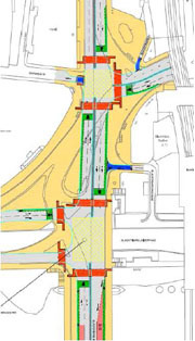
I will be joining the LCC Flashride over Blackfriars Bridge planned for 12th October, but whilst I accept that their proposal for a double T-junction is an improvement on the motorway-style development planned by TfL, this design is still all about vehicular cycling, right?


LCC's 'much safer design'

This plan was drawn up in 2007. Things should be brought more up-to-date. If the LCC really are committed to 'Going Dutch', then their proposals ought more accurately to reflect this.

Saturday, 17 September 2011

Mistakes past and present

The idea to code routes according to the direction of travel occurred to me some time after I had gotten lost whilst cycling from Greenwich to Wimbledon. As I recall, I reached the end of this residential street and then, lo' and behold, no signs. Which way now? I think I turned left but I would have gone straight on if I could.

Within a few months of having this idea, Chris Bainbridge invited me along to a BCOG meeting, but I think I upset John Lee a bit by criticising the standard of the waymarking. It seemed to me then, and still seems to me now, very worthwhile to get a comprehensive, city-wide cycle network to function, even at a minimum level.

It was health and safety considerations that prevented  the London Cycle Network being properly signed. If a section of route wasn't thought to be safe enough for an unaccompanied twelve year-old child to use, then it couldn't be waymarked. That's why the boroughs painted white lines on the pavement, because they wanted routes that were safe, and they didn't have enough money to do the job properly.

Anyway, this single policy effectively made such waymarking as there was utterly redundant. If you knew where you were going you didn't need the signs, and if you didn't know where you were going you couldn't rely on the signs.

Safe Walking Route

The LCN+ sought to smooth all the jaggedy lines that were a feature of its forebear by developing a high-profile 'spine' network of cycle priority routes. But although this network was very much aimed at a different user, the commuter cyclist, the standard of design was still high.

A London Assembly Transport Committee report on the LCN+ published in November 2005 said that the LCN+ will be characterised by a socially inclusive cycling environment where high quality standards are maintained. Sounds great. The routes themselves will be continuous, fast, safe, comfortable and easy to use. Copenhagen, eat your heart out!

However, as the report percipiently noted: 'Completion depends on the participation of all London boroughs, which is uncertain, and on the promotion of cycling up the transport hierarchy, which seems unlikely.'

One of the recommendations which emerged from this report was as follows: 'TfL and Camden should take a much more strategic approach to the implementation of the LCN+, route-by-route rather than kilometre-by-kilometre. TfL and Camden should identify a small number of key routes across London
and prioritise their early completion.'

The idea was that these routes would encompass ‘difficult’ areas such as Parliament Square or Marylebone Road, and you know, go across London, but TfL definitely understood the route-by-route bit, as we see now with the Cycle Superhighways.

The seventy or more routes that make up my design mostly comprise the LCN and LCN+. If I re-jigged things around a bit, I probably could incorporate most of the CS routes as well, but if I did that, something else would have to give. A good example is CS1 vs. LCN10: it's really got to be one or the other. Or CS11 vs. LCN50. There's one or two others as well. The only thing I would say about this is, don't decide now! Look first, and then decide.


A strategic cycle network for London was first proposed by the LCC back in 1978. Sixteen years later the LCN was launched. This simple fact should tell you everything you'd want to know about the realities of cycle campaigning in Britain. Sixteen years just to get started.

There obviously were problems with the design of the LCN, but I have maintained from the start that TfL did not need to abandon two-thirds of this network just in order to create the LCN+. It seems to me that TfL had another choice than to reduce the extent of the network, and that is to reduce the level at which the network functions. By all means, straighten the course of the routes. But there is every advantage to making the most of quiet routes, particularly the good ones.

I think, when all is said and done, it basically comes down to a choice between a network which is 100% functional and x% safe, or one that is y% functional and 100% safe (where x is actually a much, much higher number than y).

Incidentally, I was delighted at the way Mark Ames responded to Cyclenation's comment about the need to do some baselining: 'The embassy will succeed or fail by the extent to which it changes the way people view cycling in this country, not by the number of miles of Dutch-style infrastructure built.'

As long as the exception is not made into the rule, I am not aware of any benefits attached to the use of the private car for short journeys in built-up areas, at least during daylight hours. Comparatively there are numerous benefits attached to the use of the bicycle. It should therefore be possible to appeal to people directly. I mean, politicians and bureaucrats might be impenetrably dense, but from what I know of the people around me, they generally seem open to a good idea.

Photo credit: Joe D / crotch.net

As a minimum, I believe that the routes on a comprehensive, city-wide cycle network should be able to be used in both directions. One of the more difficult questions to answer when considering the development of such a cycle network is, For whom is it being designed? We have seen that so far the emphasis has been on the commuter cyclist and the unaccompanied twelve year-old child. For many years now, my thought has been that since it is only existing cyclists who are being killed on their bikes, that the cycle network should be designed with them in mind, first and foremost.

I am reluctant to stray too far from this position, but having considered the matter further since my last blog, I would like to take a much more well-defined step towards the European model. A cycle network should be developed for the riders of these bikes. The riders of these bikes will do everything that is necessary to make all of the network safe for children, even including those hostile bits that David says there is no point in waymarking.

Image from the Cycling Embassy of Great Britain


Tuesday, 6 September 2011

Tales from the saddle

It was a very representative bunch of bicyclists that gathered for the launch of the Cycling Embassy a few days ago. I didn't get the chance to talk to everyone, unfortunately, but those I did speak to told me tales which I think would be familiar to anyone reading this. 

One of the friendly faces I met talked about the urge to pick up your pace when cycling in fast-moving traffic, and that was certainly something I could relate to. Normally I like to potter along at about 12 - 14 mph, but on faster roads I suppose I just feel more secure if I'm travelling quicker. You've got to go with the flow, really, or else you might be all gobbled up. It's only when there is no pressure from behind that you feel relaxed enough to travel at a more leisurely rate, I find.

Not everyone who turned up on the South Bank was happy enough to cycle on roads with fast-moving or heavy traffic, of course - it was, as I say, a very representative bunch - and I was fascinated to hear another friendly face relate how he had plotted the route of some twelve miles' distance, from Twickenham to Lambeth Bridge, that both he and his wife could use. This task is not nearly so time-consuming as it used to be, by the way, thanks mainly due to Cycle Streets, who have even gone to the trouble of allowing users to refer to Google Street View at every turn so that, when they get to those trickier bits, they can get a virtual idea of what they'd need to do on the day. As someone who uses quieter routes more often than not, I understand very well how easy it is to get a bit lost and how difficult it then becomes to work out where exactly you are on the map.

I can see that you wouldn't want to be flustering about in front of the missus an' all, trying to work out where to go next, but isn't it just a little bit strange that this sort of prior preparation and planning is even necessary? Nothing at all against Cycle Streets, of course, who are making the best of the current situation. But just to give you some idea of how things stand at the moment, when I pasted details of the fastest route option of this particular journey into Word, the document ran to nine pages. Comparatively, I could describe the same journey, pretty much, with just a letter and a number (and some proper waymarking, of course). 

One of the more interesting conversations I had was with a chap from Inclusive Cycling, who said in his blog that the Cycling Embassy is 'a group calling for the kind of high quality cycling infrastructure that everyone can use.' Hear, hear to that.

And then there was this other bloke, a family man who worked in Canary Wharf, who just wanted his kids to be able to cycle to school. Yeah, why not?

Whoever they were, and however far they'd come, all of those who turned up presumably shared a desire to see Britain move away from the passé style of urban planning so common in our towns and cities, and exemplified in such schemes as the Blackfriars Development.

Looking again at TfL's 'vision of the future', I am struck by just how jolly uncivilised it is. I am also intrigued by TfL's forecasting. Motor vehicular traffic - excluding buses, taxis and motorbikes - is expected to make up just fifteen per cent of the modal share of journeys through Blackfriars Junction. So why on earth are TfL not designing a streetscape that reflects this? It's absurd.

15% of the modal share should not require 85% of the available space (which it how it looks to me, if you include the traffic 'islands'). Someone is being very unimaginative, it seems to me.  

Sunday, 4 September 2011

City Cycling

I went along to the Skyride today. I approached Trafalgar Square via The Strand, which was choc-a-bloc, no doubt because Victoria Embankment was closed to traffic.

I handed out my small bundle of Embassy post-cards, and then joined the throng of cyclists alongside the river. The thing that I found particularly striking was that the noise was different. You could hear people laughing, for instance.

As I was riding around I had a quick look at Blackfriars Bridge. The case is, TfL are not making the best use of the available space. Obviously they are not thinking in terms of a network, and obviously they are not thinking about segregated cycling.

Image from Cyclists in the City

If there was to be a segregated two-way cycling track, it would make most sense to put it on the eastern side of the bridge. I imagine that most of the cycle traffic crossing the bridge from the south would either want to go straight on towards Farringdon or turn right towards the City.

For those wanting to turn left onto Victoria Embankment, I can see where I'd put the crossing and the segregated lane. Probably you can too. Under the current plans, however, look at what you'd need to do for the return journey. I think this is completely unacceptable.

Again, we need to look at the entire length of this route, that is, from St. George's Circus all the way up to York Way and beyond. We need to submit an alternative proposal for the Mayor to consider, which has been properly designed and fully costed up.

Another thing to say is that if we really do want to see 'a network of direct, well-designed, separated cycle routes', then one of the keys to success, I think, would be the City. I say this for a number of reasons. Firstly, they are the major employer in London, and therefore very influential. Secondly, given that the benefits of the bicycle are so numerous and so compelling, I believe they can be persuaded to consider the business case. Thirdly, given that most trends tend to start with the ABC1s, they can lead the way and show their fellow Londoners that the bicycle is indeed by far the best way to get around.

I have prepared a map showing the extent of the cycle network in the City (plus environs). The key is as follows: blue - segregated cycle tracks; red - shared cycling or no change; pink - local routes.